The route
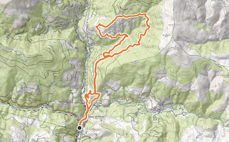
This is a demanding circuit that starts with a considerable up slope that after 12 kms will take you to Balandrau´s summit. After that, the route mainly consists in passing across some cols and crests, reaching a total of 4 peaks (2000m in height).
The high point of the trail is the Balandrau, an emblematic summit within the hiking practice in Cataluña and also a vantage point over the Coma de Vaca valley and the eastern Pyrenean peaks.
Departing from the Tourist office, go cross the town towards the remains of Castell de Sant Pere and walk up the staircase beside the castle. Go past the urbanisation and pass the fence, leaving it closed again. From there, you will start the constant uphill track that will lead you to Can Nadal. Once there, turn left and walk a paved path for 100m, until you find a path on your right. Take it and continue on that path until you come across the track in Ribes-TreguràRibes-Tregurà. Go across it and you will directly get to the next path that should be followed on a steeper slope. When you get to a sign, turn left and you will do a short descent among trees. This will bring you to a forest track that will get you across the Torrent de Serrabona without losing height. Keep walking the milled way towards El Serrat, entering it via the hermitage of Verge del Remei, crossing the town and leaving it by a wide path that will lead you to an antenna. At that point, leave the path and turn right to continue climbing across the fields , until you get to the next track. Follow it on a steeper climb that will bring you up to 1600 meters high, to the Camino de los Collets.
After crossing the track of Collets, continue ascending across fields and wide paths, followed by a trail through the forest until you reach Llanos del Atalaiador, the highest point of this route so far (2000m in height). Pass by the Atalaiador summit, going across the fields on the crest while enjoying the spectacular views of Vall de Ribes. Keep going up, facing towards Roques Blanques, the next target. Once there, there is a flatter stretch from where you could admire the first views of the Balandrau summit. At that stage, you just have left the last part of the ascent to reach the top of the peak (2564m in height).
After admiring the superb views from that summit, retrace your steps till the base of the last part of the ascent. Keep descending through the crest of Serra de la Canya all the way to Coll de los Treguradesos. That crest stretch is very wide and easy to follow, always by fields. It will get you directly to Cerverís (2208m in height), second summit reached in this route.
Continue through the south crest of the peak until you find the Collada de Meianell. Contrasting with the trail across the fields that cover these pyrenean landscapes, there is a short stretch by track at that point, that will lead you to the peaks Mont-Roig and Pel-de-ca (1900m height). Leaving behind the second of this peaks, pass a fence and start going down parallel to another fence, this time by a less visible path and dodging trees and bushes. At some point you will come across a wide and milled path that should be followed to keep descending towards the Collada Verda.
The Collada Verda is the traditional natural walkway for trading exchange between the valleys of Camprodon and Ribes. After crossing this place you will shortly come across the source of the Segadell river. This is the only access to water that you will have until the end of the route. Continue the gradual climb across the fields until you meet the Coll de Pal and from there, keep moving along the crest of Serra Cavallera.
That green and wide crest, on a constant climb, will bring you to Puigestela peak, the third highest summit reached along the route (2013m high). Leaving this peak behind you, keep moving along the crest, finding some stretches a bit more challenging on your way down to Portella de Ogassa. Just like Collada Verda, this hill has been a natural walkway for livestock trading between both mountain ranges for many years. From there, if you look upwards you will find the Taga, last target of the trail that will be reached after a gentle climb.
You will pass by the Cross that overlooks a big part of the catalan region. After admiring the views and having a break, it is time to start the descent. The beginning is easy, just following the crest; but after a while, the slope will get quite steep. According to the speed of your way down, you will see how Ribes de Freser gets closer and closer. Leaving the fields behind you, get inside the forest through a milled way that will lead you to Plans de Conivella, starting here a flatter stretch. Continue beside a fence until its end and turn right to keep going by track for 200m. Take a hidden path on your left and keep going down there until Collet dels 7 Fortins. Cross it and pass by 2 fences to keep descending through the forest once more.
After a trail of dodging trees and big roots, you will get to the new deposits. There is a short walk, without losing height, until you get a turn to the right to continue going down all the way to the Caterineta fountain. Once you are back in town, pass by the pavilion and Paseo Àngel Guimerà to retrace your steps back to the Tourist office.